Seohaerang Trail (Gochang, Gunsan Section)
8 stops · 3 nights or more
The Gochang-Gunsan section of the Seohaerang Trail is a course where you can encounter traces accumulated over time from various angles and perspectives. It features the vast expanse of the Myeongsasimni Beach, reminiscent of fine white sands often imagined on the East Coast, as well as a biosphere reserve where tidal flats—known as the lungs of the Earth—spread across the sea and land like capillaries. Walk along the Gochang-Gunsan section of the Seohaerang Trail, ready to capture entirely new memories that transcend stereotypes of the West Sea.
- Duration
- 3 nights or more
- Distance
- 101.5km
Along the way
- 1
Gusipo Port
구시포항
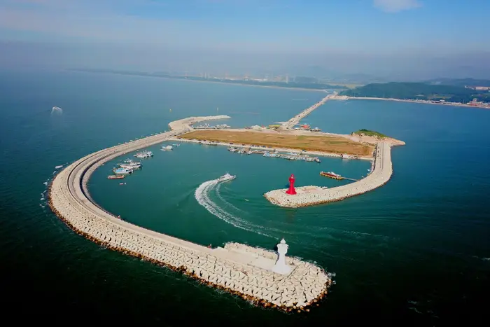
This port has been producing salt since around 1800. It got its current name because the water gate built to cultivate the salt pans resembled a cow's feed trough (gusi, a dialect word for guyu). The surrounding scenery is beautiful, earning it a spot on the Ministry of Oceans and Fisheries' list of the '100 Beautiful Fishing Villages.' It is also well known for Gusipo Beach, which boasts a dense pine forest and a wide, firm sandy beach, as well as seawater baths. Located at the southern tip of Gochang, Gusipo Port sits on an island called Gamakdo, separated from the mainland unlike typical ports. It provides favorable conditions for fishing boats to enter and depart without being significantly affected by the tides. Renovated widely in the shape of a wine glass, the port features an 800-meter-long breakwater extending into the sea, a lighthouse, an observation deck, trick art, and a park, allowing visitors to enjoy the port in a more pleasant and entertaining environment.MoreLess
- 2
Gochang Dolmen Site [UNESCO World Heritage]
고창 고인돌 유적 [유네스코 세계문화유산]
About 4 km from Gochang-eup, beside the crock stand behind Mr. Kim Yeong-in's house in Jidong Village, Dosan-ri, sits a neatly arranged northern-style dolmen (made by erecting flat stones high on both sides and covering them with a capstone). Walking about 3 km toward Seonunsa Temple brings you to a dolmen group spanning 2 km across Sanggap-ri, Asan-myeon, and Jukrim-ri, Maesan-ri, and Songam-ri in Gochang-eup. Here, 447 dolmens, including a massive one estimated at 150 tons measuring 5 m long, 4.5 m wide, and 4 m high, are marked with individual identification numbers in white paint. This dolmen group offers a glimpse into village settlements and life back in the Bronze Age. On November 29, 2000, it was inscribed on the UNESCO World Heritage list alongside dolmen sites in Ganghwa and Hwasun, around which time the heritage sites throughout Sanggap-ri and Jukrim-ri were meticulously organized.MoreLess
- 3Ungok Ramsar
운곡 람사르
'Gochang Ungok Ramsar Wetland', home to the UNESCO World Heritage Dolmen Site Ungok Ramsar Wetland is a low-lying hill wetland designated as a wetland protection area due to its high ecological value. Boasting rich biodiversity with a total of 864 species of flora and fauna, it holds significant conservation value as an ecological habitat for endangered wildlife and rare species. It is also a historic site rich in historical and cultural resources, such as the Gochang Dolmen Site and Seosan Mountain Fortress. As the only place where visitors can encounter a diverse array of UNESCO-designated dolmens, it serves as a regional treasure trove of living ecological history. It is a tourist destination where the natural environment is well preserved, offering various ecotourism programs.MoreLess
- 4
Byeongbawi Rock (Jeonbuk West Coast National Geopark)
병바위 (전북 서해안 국가지질공원)
Named for its resemblance to an upside-down bottle, Byeongbawi Rock is associated with an amusing legend that an intoxicated Taoist immortal kicked a drinking table, causing a wine bottle to stick upside down and turn into rock. Depending on the viewing angle, Byeongbawi also looks like a human face. This rock formation was shaped through the weathering and erosion of rhyolite. Because the rhyolite of Byeongbawi is harder, denser, and more resistant to weathering than the surrounding lapilli tuff, visitors can observe the splendid landscape of steep vertical rhyolite cliffs and typical tafoni structures formed by differential weathering between rhyolite and lapilli tuff, giving it immense geological value. Furthermore, it serves as an educational site demonstrating how the differential physical properties of rock facies act as crucial geological factors in shaping topographical landscapes.MoreLess

- 5
Chaeseokgang Cliff (Jeonbuk West Coast National Geopark)
채석강 (전북 서해안 국가지질공원)
Formed by the accumulation and seawater erosion of sediments since the Cretaceous period of the Mesozoic Era about 70 million years ago, this sedimentary rock belongs to the Gyeokpori Formation and consists of alternating layers of conglomerate, sandstone, mudstone, shale, and volcanic ash atop conglomerate beds. This depositional environment suggests that the area was once a deep lake where volcanic ejecta settled at the lake bottom. The cliff offers clear views of faults, folds, intrusive structures, and wave-cut platforms, making it an excellent site for topographical and geological study. Sea cliffs, flat wave-cut platforms, and sea caves created by wave erosion are well developed. On the seabed of Chaeseokgang Cliff, potholes formed by the combined action of the crust and waves are prevalent, along with tidal pools created by trapped seawater at high tide.MoreLess
- 6Suseongdang Shrine
수성당
Suseongdang Shrine is located on the cliff of Jeokbyeokgang, 2 km along the coastline from Gyeokpo Beach. It is a marine shrine dedicated to Gaeyang Halmi, the guardian goddess of the Chilsan Sea, where a village ritual (dangsanje) is held annually on the 14th day of the first lunar month. Gaeyang Halmi is a sea goddess reverently worshipped by all local residents; legendary for her immense height, she was said to walk across the West Sea in high wooden clogs, filling in deep waters and calming wind and waves to protect fishermen and passing vessels. She is said to have had eight daughters, living with only the youngest at Yeoulgul Cave next to Suseongdang Shrine while marrying off the remaining daughters to nearby islands so they could protect the fishermen there.MoreLess
- 7Seonyudo Beach (Myeongsasimni Beach)
선유도해수욕장 (명사십리 해수욕장)
Located in Okdo-myeon, Gunsan-si, Jeollabuk-do, Seonyudo Beach is a natural coastal dune beach often called Myeongsasimni Beach for its vast expanse of beautiful, crystal-clear white sand. At Seonyudo Beach, the water remains only waist-deep even after walking about 100 meters in, and the absence of high waves allows for safe swimming.MoreLess
- 8
Wolmyeong Park
월명공원
Wolmyeong Park is a renowned attraction in Gunsan that connects Mount Wolmyeongsan, Janggyesan, Seollimsan, Jeombangsan, and Seokchisan, and it was once the most popular school excursion destination in Gunsan during the 1960s and 70s. It is a massive park covering an area of about 2.55 million square meters with walking trails stretching 12 km. Spanning Haemang-dong and Sinheung-dong, climbing up to the Susitap Pagoda—the symbol of both Gunsan and Wolmyeong Park—offers a panoramic view of the sea off Gunsan, the Geumgang Estuary Bank, Gunsan downtown, and the Janghang Smelter. At the park's summit, there are an observatory, the Sea Sculpture Park, Susitap Pagoda, the March 1st Movement Monument, the 35th Anniversary of Port Opening Monument, the Thinking Citizen Statue, and the Chae Man-sik Literary Monument. Susitap Pagoda takes the shape of a blazing flame and sails fluttering in the wind. At the western foot of Mount Seollimsan within the park lies the ancient temple Eunjeoksa, alongside the First Reservoir created by damming between Mount Jeombangsan and Seollimsan. The park is beautifully landscaped with lush wisteria and cherry blossom trees over 30 years old, creating picturesque scenery. A nationwide cherry blossom photo contest is held every April. While it is lovely in all four seasons, the park is at its most stunning in spring when the cherry blossoms are in full bloom.MoreLess
Source: Korea Tourism Organization (TourAPI) · Machine-translated