Namparang Trail (Goseong, Tongyeong Sections)
7 stops · 3 nights or more
The Namparang Trail is the southern coastal section of the Korea Dule-gil trail network connecting the east, west, south, and north of Korea. It is a 1,470 km walking trail comprising 90 sections in total, stretching from Oryukdo Island in Busan to Ttangkkeut Village in Haenam. Meaning "a trail walking along the southern indigo sea," it was officially opened on October 31, 2020. This course introduces the sections in Goseong and Tongyeong. Visitors can explore Sangjogam County Park, where dinosaur footprints were first discovered in Korea, the historic Hakdong Village, said to resemble a crane brooding its eggs, and Dongpirang Village, renowned for its murals.
- Duration
- 3 nights or more
- Distance
- 37.5km
Along the way
- 1
Sangjogam County Park
상족암군립공원
Sangjogam County Park is located in an area of supreme scenic beauty, offering panoramic views of the Hallyeosudo waterway along the southern coast, wide rock platforms on the sea surface, and cliffs of bizarrely shaped rocks forming valleys. Goseong-gun designated this area as a county park by official notice on November 10, 1983, recognizing the conservation value of the natural treasure Sangjogam and the distinct dinosaur footprints from the Cretaceous period of the Mesozoic Era. The beach in front of the Youth Training Center is covered with pebbles worn smooth by the constant washing of the tides. Past the wide rock platform with dinosaur footprints, the entire face of the mountain forms stratified sheer cliffs. In addition, the cave that winds deeply east and west inside the rock face is called "Sangjok" because it resembles the legs of a dining table, and is also called "Ssangjok" or "Ssangbari" because it looks like multiple legs. Sangjogam, formed of rock caves, features high and low, wide and narrow caves containing curiously shaped stones steeped in many legends. Legend has it that in ancient times, heavenly fairies descended here to set up a stone loom and weave golden garments for the Jade Emperor at Sangjokgul Cave, and that the fairies bathed in a pool called Seonnyeotang. To this day, a stone formation resembling a loom and a pool shaped like a bathtub remain inside the cave. Nearby Candlestick Rock (Chotdaebawi) and Folding Screen Rock (Byeongpungbawi) add to the splendid scenery, while sightseeing cruise ships glide between Saryangdo Island in Tongyeong, creating sprays of white water. The breathtaking view of Hallyeosudo stretching before one's eyes attracts visitors all year round. The Sangjogam area evokes a sense of mystery with its preserved fossilized dinosaur footprints. They were first discovered between January and February 1982 when Professor Yang Seung-young of Kyungpook National University and Professor Kim Hang-mook of Pusan National University surveyed along the coastline from Gwangyang, Jeollanam-do, to study the fossil distribution in Korea. This site is counted among the world's top three dinosaur fossil sites, along with areas in Brazil and Canada. These footprints were left by dinosaurs such as Brontosaurus, Brachiosaurus, Allosaurus, and Tyrannosaurus, which became widely known through the movie Jurassic Park. The dinosaur footprints around Sangjogam are designated and protected as Natural Monuments as precious resources offering a glimpse into the mysteries of Earth long before humankind appeared.MoreLess
- 2
Old Walls of Hakdong Village, Goseong
고성 학동마을 옛 담장
Hakdong Village in Goseong is a historic village said to have been founded around 1670. An ancestor of the Jeonju Choe clan dreamt that a crane (hak) came down to the village and brooded its eggs. When day broke, he visited the site and found that the landscape was truly scenic and formed the shape of a crane brooding its eggs. Believing it to be an auspicious site, he settled here and named it Hakdong. Currently, the mountain ridge of Sutaesan rises behind the village and Jwasan rises in front, forming a topography known as "Blue Dragon on the left and White Tiger on the right." Hakrimcheon Stream flows beside the village, perfectly illustrating the traditional location principle of "facing water with hills behind" (baesanimsu). While many of the village houses were modified with slate tiles during the Saemaul (New Village) Movement, some traditional houses such as the Cultural Heritage Materials "Yukyeongjae" and "Choe Clan Old House" are preserved, maintaining the character of a traditional village. The stone walls of Hakdong Village have a unique characteristic unseen in other villages, built in neat layers combining flat stones (flagstones 2 to 5 cm thick) gathered from the Sutaesan ridge with red clay. The building foundations and terraces in the rear garden are also built with stone retaining walls using the same method, creating harmony. Blending seamlessly with the surrounding bamboo groves imbued with southern charm, the long stone-walled alleys make visitors feel as if they are stepping back centuries into an ancient castle, creating picturesque scenery. Walking along the clay-hued stone walls evokes a wistful sense of rural nostalgia. * Walls - Approx. 2,300 m long stone walls (flat stones) and earth-and-stone walls * Construction style - Layered courses using slate-type stones and red clay * Village formation - Formed in the late 17th century; currently 50 households (108 residents) reside here * Cultural heritage - 2 items including Old House of Choe Yeong-deok in Hakrim, Goseong (Cultural Heritage Material)MoreLess
- 3
Munsuam Hermitage (Goseong)
문수암(고성)
Munsuam, a branch temple of Ssanggyesa Temple of the 13th District of the Jogye Order of Korean Buddhism, is a hermitage located on Muisan Mountain in Museon-ri, Sang-ri-myeon, Goseong-gun. It was founded by Great Master Uisang in the 5th year of King Seongdeok of Silla (706 AD). Since its founding, this hermitage has produced many eminent monks as a practice site. Renowned as a scenic spot in Korea since the Three Kingdoms period due to its beautiful mountain landscape, it is said that Hwarang warriors cultivated their minds and bodies on this mountain during the golden age of Hwarangdo. However, the history of its reconstruction and renovation has not been passed down. The current hermitage consists of modern buildings constructed after previous structures collapsed during Typhoon Sarah, and it houses the Stupa of Great Master Cheongdam, erected in 1973 with donations from lay believers to enshrine the sarira of Monk Yi Cheong-dam, who practiced at this temple. Because images of the two Bodhisattvas Manjusri (Munsu) and Samantabhadra (Bohyeon) appeared on the rock wall, it was named Munsudan. The statue of Manjusri Bodhisattva is carved in stone, while the statue of Avalokitesvara Bodhisattva (Gwaneum) is a wooden carving measuring 2 ja and 7 chi (approx. 82 cm). Bizarre rock cliffs surround the back of the hermitage like a folding screen, and reaching the summit offers an exquisite panorama of numerous islands of Hallyeohaesang National Park along the southern coast rising and falling like mountain peaks, making it a historic Silla temple visited constantly by hikers and tourists. Sutaesan Bohyeonsa Temple is located nearby. It takes about 30 minutes by bus from Sacheon Airport, and the road is paved up to the entrance of Munsuam. Visitors can drive along the winding mountainside road, park at the lot just below Munsuam, and walk for about 10 minutes to reach the hermitage. The following legend is passed down regarding its founding: When Great Master Uisang was on his way to Mt. Bogwangsan (present-day Mt. Geumsan) in Namhae to pray, he lodged in a village in Museon-ri, Sang-ri-myeon. In a dream-like state, an old monk appeared and said, "Tomorrow morning, follow a beggar and visit Mt. Muisan before Mt. Bogwangsan," before vanishing abruptly. Waking up, Uisang realized it was a dream. When day broke, a beggar indeed appeared. Uisang quickly served him a meal and asked for directions to Mt. Muisan. Hearing that the beggar was heading there, Uisang accompanied him. Following the beggar halfway up Mt. Muisan, he saw countless islands floating before his eyes, and five magnificent rocks forming "Five Terraces" (Odae) in the east, west, south, north, and center, reminiscent of the Central Terrace of Mt. Odaesan. At that moment, the beggar pointed to the Central Terrace and said, "That is my bedchamber." Then another beggar appeared, and the two beggars held hands and disappeared into a crevice in the rock. Master Uisang looked between the stone walls, but the beggars were nowhere to be seen; instead, only a natural image of Manjusri Bodhisattva miraculously appeared on the rock. Master Uisang attained sudden enlightenment, realizing that the old monk in his dream was Avalokitesvara Bodhisattva and the two beggars were Manjusri and Samantabhadra Bodhisattvas. Looking around Mt. Muisan, Master Uisang praised it, saying, "This place is worthy of taming lions and is truly a training ground of landscape and practice." He then gathered Munsudan and founded Munsuam Hermitage. Even today, the natural image of Manjusri is said to appear distinctly between the stone walls.MoreLess
- 4
Ancient Tombs in Songhak-dong, Goseong
고성 송학동 고분군
The Ancient Tombs in Songhak-dong, Goseong, consist of seven Gaya tombs presumed to be the graves of the political rulers of the time. They feature diverse tomb styles, including pit-style stone chamber tombs—a representative construction method of the Gaya period—as well as corridor-style stone chamber tombs and stone-lined tombs with horizontal entrances. They are estimated to have been constructed around 400 AD, within a range of about 50 years before or after. Tomb No. 1, which had been the subject of controversy as a keyhole-shaped tomb (zenpokoenfun), sits at the highest point, while the remaining six tombs are situated progressively lower down. The Giwon-ri Tombs lie 300 m to the north, and the Songhak-dong Shell Midden is located 300–400 m to the east, indicating the historic territory of the Sogaya Kingdom during the Three Kingdoms period. Tomb No. 1 might appear from the outside as a keyhole-shaped tomb (square in the front and rounded in the back) commonly seen in Japan's Kofun period, but excavation revealed that it was made by mounding earth into a hill-like shape and then constructing stone tomb chambers. These seven tombs are closely related to Tomb No. 1 (the Mugisan Tomb) and also served as auxiliary tombs (satellite tombs) to protect Tomb No. 1. In particular, the Area B tomb of Tomb No. 1 is a corridor-style stone chamber tomb preserved in good internal condition, and is the first painted ancient tomb identified in Korea. Artifacts excavated from this site include diverse relics from Silla, Baekje, Japan, and the Gaya regions, serving as highly valuable research material for archaeological studies examining relations with Japan and drawing frequent visits from Japanese academic circles. To the northeast lies the Goseong Dongoe-dong Shell Midden, where remains such as wooden coffin tombs (pit graves), jar coffin tombs, and stone cist tombs have been uncovered, alongside artifacts including bronze socketed spears (bronze gwangmo), bronze sword pommel ornaments, mirror fragments, charred rice, and gray pottery, providing insight into the culture of this region. ※ According to the test and excavation surveys of the Songhak-dong Ancient Tombs conducted in 1999–2000, it was determined that Tomb No. 1 was not a keyhole-shaped tomb, but rather formed of three conjoined tumuli.MoreLess
- 5
Namsan Park (Goseong)
남산공원(고성)
This is the only urban park in Goseong that offers a panoramic view overlooking the entire town of Goseong-eup. At the park entrance, monument stones honoring the deeds of ancestors are neatly arranged. Walking up the 84 steps, visitors encounter Bogwangsa Temple, a branch temple of Okcheonsa Temple of the Jogye Order of Korean Buddhism. To the right of Bogwangsa Temple stand a Memorial Tower, an Enshrinement Pavilion, and an Anti-Communist Monument from the Korean War, erected to honor the souls of patriotic martyrs. In front of Bogwangsa Temple, crystal-clear groundwater is provided for visitors climbing Namsan, which is widely enjoyed as drinking water. Recently, physical fitness facilities and the Magnolia Rest Area were developed along the ridge above Bogwangsa Temple, creating an ideal relaxation space for both exercise and rest that is frequently used by local residents. From here, a well-paved walking trail with a width of 3 to 4 meters leads over the mountain summit down to Sunam-ri (Cheoltuk) and Sinwol-ri. It takes about an hour to complete the trail, offering an optimal environment as an urban hiking course and gaining popularity as a winter training site for professional track and field athletes. From the summit, one can look down at Goseong Bay and downtown Goseong all at once. An octagonal pavilion stands here, serving not only to promote the health and relaxation of townspeople, but also as a warm and scenic spot that makes hikers reluctant to leave.MoreLess
- 6
Haejigae Bridge
해지개다리
Built in Sinwol-ri, Goseong-eup, Haejigae Bridge spans across the sea and is loved as a popular dating spot for couples, carrying the meaning that "the beautiful sunset over the vast lake-like sea naturally brings to mind one's loved ones or those dearly missed." The bridge measures 3.5 meters in width and 209 meters in length. In addition, the Haejigae Coastal Trail is a 1.4 km one-way section connecting Nampo Port to Namsan Auto Camping Site, the sea deck bridge, and Guseonchang. With nocturnal landscape lighting installed, an increasing number of people visit for night strolls. The decorative lights are turned on from sunset until 11:00 PM. Take a walk along the sparkling Haejigae Bridge at night to heal your weary body and mind.MoreLess
- 7Dongpirang Village
동피랑마을
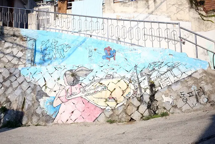
The name "Dongpirang" was created by combining the words "dong" (east) and "birang." "Birang" is the Tongyeong dialect word for "slope" (bital), and people began calling it "Dongpirang" by taking only "dong" (meaning east) and attaching it to the front. In October 2007, the Green Tongyeong 21 Promotion Committee gathered painters from across the country to paint along Dongpirang-gil. These artists painted murals across the village walls, fences, and alleys, transforming this seaside hillside village into an open-air canvas. Dongpirang has dozens of branching alleyways. Every alley features paintings, and this village reaching toward the sky is filled with artwork sufficient to turn the village into a fairytale world. The view of Gangguan Port and the open sea overlooking from the village is also well worth seeing.MoreLess
Source: Korea Tourism Organization (TourAPI) · Machine-translated