The Secret Scenery of Hantangang River Commanded by Im Kkeok-jeong
6 stops
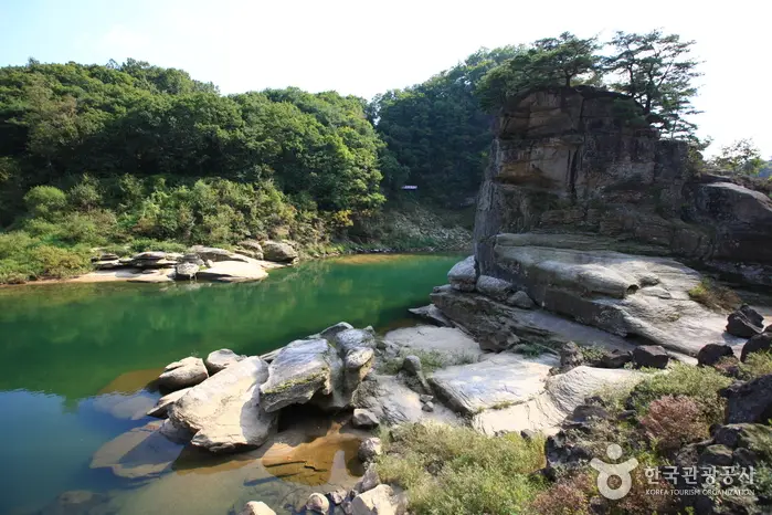
The Hantangang River gets its name from the Chinese characters for Milky Way (Han) and rapids (Tan), meaning 'great rapids' in Korean. Beautiful for its great rapids, the Hantangang River was formed by volcanic activity. When the water level is high at Goseokjeong, the lower rocks become submerged, turning it into a rocky island; to enjoy it more vividly, taking an excursion boat is recommended. Explore thoroughly the beauty of the fantastic rocks and bizarre stones around Goseokjeong. Scenic spots carved out by the Hantangang River include Songdaeso, Madangbawi Rock, Jiktang Falls, and Sundam Valley.
Along the way
- 1Goseokjeong National Tourist Area
고석정국민관광지
Goseokjeong is one of the Eight Scenic Views of Cheorwon and the foremost scenic spot in Cheorwon. Jade-clear water swirls and flows on both sides of a 10-meter-high bizarre rock rising in the middle of the Hantangang River. It is said that King Jinpyeong of Silla built a two-story pavilion of about 33 square meters (10 pyeong) along the midstream of the Hantangang River and named it Goseokjeong; the entire valley around this pavilion and Goseokbawi Rock is collectively called Goseokjeong. Designated as Local Monument No. 8, Goseokjeong is said to be a place visited and enjoyed by King Jinpyeong of Silla and King Chungsuk of Goryeo. Goseokjeong became even more famous as it was known as a stronghold of Im Kkeok-jeong (?-1562) during the reign of King Myeongjong of the Joseon Dynasty. MoreLess
- 2
Cheorwon Peace Observatory
철원평화전망대
The Peace Observatory was completed in 2007 after the nearby Iron Triangle Observatory lost its function due to overgrown trees. Offering a panoramic view of the Demilitarized Zone (DMZ) along the central front line in Cheorwon-gun, Gangwon-do, and North Korean territory, the observatory features exhibits replicating the Second Tunnel, military barracks, and checkpoints, as well as DMZ photographs. A 50-passenger monorail is installed, allowing visitors to easily reach the observatory. Visitors can take in the ancient fortress site of the Taebong Kingdom and the Cheorwon Plain at a glance, and observe North Korean soldiers through binoculars.MoreLess
- 3Woljeong-ri Station
월정리역
Woljeong-ri Station is the last train station closest to the Southern Limit Line of the Demilitarized Zone (DMZ). Visiting Woljeong-ri Station, one can see a stopped train beside a sign reading, 'The Iron Horse wants to run.' During the Korean War (Korean Conflict), the North Korean military took only the front part of the train when retreating, leaving behind only part of the rear section used as passenger cars. Located in the Iron Triangle where some of the fiercest battles took place during the Korean War (Korean Conflict), the stopped train at Woljeong-ri Station is an emblem symbolizing Korea's history of national division. Currently, Cheorwon Woljeong-ri Station (Iron Triangle Observatory) is operated by Cheorwon-gun as a security tour course and attracts many tourists every year.MoreLess
- 4
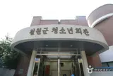
Cheorwon Youth Hall (Grey Heron Habitat)
철원청소년회관(왜가리서식지)
Located in the town center about 15 km from Hantangang Resort and the tunnel, this facility is convenient for youth training activities. Nearby attractions include Goseokjeong National Tourist Area (5 km), Jiktang Falls (7 km), Dopiansa Temple (13 km), Pochunsa Temple (12 km), Sambu yeon Falls (2 km), Chungnyeolsa Shrine (12 km), Maewoldae (30 km), Toseong (12 km), the Second Tunnel (25 km), Observatory (25 km), Baengma Goji (20 km), Korean Workers' Party Headquarters (15 km), Migratory Bird Habitat (18 km), Grey Heron Habitat (14 km), and Dolmen (12 km).MoreLess
- 5Cheorwon Korean Workers' Party Headquarters
철원 노동당사
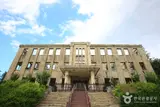
The Korean Workers' Party Headquarters, located in Gwanjeon-ri, Cheorwon-eup, Gangwon-do, is a three-story building completed in 1946. It was used as the Workers' Party headquarters of North Korea until the outbreak of the Korean War (Korean War). Having suffered severe damage during the Korean War, the entire building is now blackened by fire and heavily riddled with bullet and shell marks. However, as this appearance evokes the Korean War and the reality of Korea's division, it has also been used as a filming location for famous singers' music videos and a venue for notable concerts. Currently, Cheorwon Korean Workers' Party Headquarters is operated by Cheorwon-gun as a security tour course and attracts many tourists. Registered as a Modern Cultural Heritage in February 2001, it is protected at the governmental level.MoreLess
- 6
Soisan Ecological Forest Green Trail
소이산 생태숲 녹색길
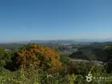
Soisan Mountain is a small mountain rising 352.3 meters above sea level over the Cheorwon Plain, located in Sayo-ri, Cheorwon-eup at longitude 127°12' E and latitude 38°15' N. After the Korean War, it was a US military base and restricted to the general public under the Civilian Control Line. However, through agreements with the Army's 6th Infantry Division, the public, government, and military worked together to begin construction in June 2011 and complete it in December, finally opening the trail in 2012 under the name 'Soisan Ecological Forest Green Trail.' Areas outside the walking trail are still minefields, so the path is walked alongside barbed-wire fences. It is the site where the No. 1 Beacon Fire Station had been located since the Goryeo Dynasty to signal foreign invasions. As the center of Cheorwon's history that remembers the glorious past of old Cheorwon before the Korean War, the summit of Soisan Mountain commands a panoramic view of Baengma Goji, Kim Il-sung Heights, Cheorwon Station, the Second Tunnel, and the Korean Workers' Party Headquarters, as well as the largest migratory bird habitat and the Cheorwon Plain.MoreLess
Source: Korea Tourism Organization (TourAPI) · Machine-translated