A Full Loop of Ulleungdo Island in a Single Day!
7 stops · 7 hours (incl. 2 hours walking)
A course touring the entirety of Ulleungdo Island in a single day using a sightseeing taxi or bus. However, since the round-the-island road is not completely connected, there is the inconvenience of having to backtrack along certain stretches. If you want to circle the whole island, you'll need to walk or trek the disconnected sections. A vehicle tour usually takes around 5 hours. It's worth combining it with the Haengnam Coastal Trail, which starts at Dodong Harbor, to make a full day course.
- Duration
- 7 hours (incl. 2 hours walking)
- Distance
- 44km (incl. 2.9km coastal trail)
Along the way
- 1
Dodong Harbor
도동항
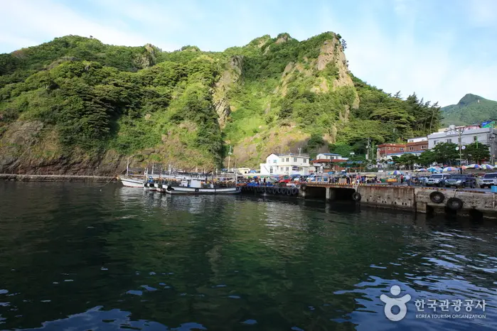
Located 188km northeast of Pohang, Dodong Harbor is a Class 2 gateway port for Ulleungdo Island. Its quay wall was built as part of the government's Ulleungdo tourism development plan, with construction starting in 1973 and completing in 1977; it can accommodate one vessel of up to 1,000 tons. Its annual cargo handling capacity is 20,000 tons, with cargo mostly consisting of daily necessities for residents and Ulleungdo squid. A place where the excitement of arrivals and the sorrow of departures wash in like waves, it greets visitors with Manghyangbong Peak on the left — which seemed to sing the homesickness of the early settlers — and Haengnam Lighthouse on the right, guarded by a 2,500-year-old juniper tree.\nMoreLess
- 2
Sajabawi (Lion Rock)
사자바위
The area to enjoy sunset scenery on Ulleungdo is along the island's western coast. The sunset at Sajabawi (Lion Rock) in Namyang-ri is a wonderful sight that anyone can easily enjoy standing comfortably nearby. Since it sits right beside the coastal road, the massive Sajabawi feels close enough to touch, and behind it, the sun setting slowly is a breathtaking sight for visitors, weather permitting. Moreover, the sight of squid drying in the coastal village of Namyang-ri, and one or two fishing boats casting shadows in the sunset light as they return listing gently to harbor, is a scene unlike any other found along the East Sea coast.\nMoreLess
- 3
Taeha Hyangmok Tourist Monorail
태하 향목 관광모노레일
This tourist monorail, which offers a sweeping view of Ulleungdo's spectacular scenery, allows visitors to comfortably take in the summit of Taeha Hyangmok. The monorail runs on a total track length of 304m, with two 20-passenger cars operating simultaneously at a speed of 50m per minute, taking about 6 minutes to reach the summit. Although the maximum incline reaches 39 degrees, the cars automatically maintain a level position at all times, so it can be ridden with peace of mind.\nMoreLess
- 4
Gongam (Elephant Rock)
공암(코끼리바위)
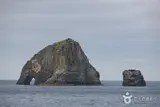
Along with Gwaneum Twin Caves and Samseonam Rock, this is one of Ulleungdo's three great scenic wonders. It is also called Elephant Rock because its shape resembles an elephant dipping its trunk into the water to drink, and it is also called Gumeongbawi (Hole Rock) because of a 10m-diameter hole in the 'trunk' section. Its surface, shaped by columnar jointing, looks as though split firewood has been neatly stacked layer upon layer, so precisely formed that it seems as if someone carved and stacked the stones by hand, drawing spontaneous exclamations from visitors. The surface of the massive rock is wrinkled like an elephant's skin, and a hole resembling an eye is set where the eye would be, giving it the unmistakable appearance of an elephant.\nMoreLess
- 5
Naribunji Basin
나리분지
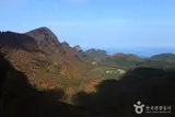
Measuring about 1.5km east-west and 2km north-south, Naribunji is Ulleungdo's only flatland, formed as a caldera crater floor when the northern crater of Seonginbong Peak collapsed. Within it, Albong Peak (611m) erupted, and lava flowing from Albong further split the crater floor into two, with Nari Village to the northeast and the now-uninhabited Albong Village to the southwest. People have lived here since the time of the Usan Kingdom, but the area was left empty for centuries under the Joseon dynasty's policy of clearing the island, until settlers came here following King Gojong's settlement decree. It is called Narigol ('lily valley') because early settlers were said to have survived by digging up and eating the roots of the island lily (seommal-nari). \nMoreLess
- 6
Seokpo Observatory
석포전망대
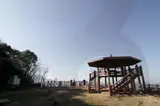
Seokpo Observatory sits in Seokpo Village, a small fishing village at the northern tip of the beautiful, mysterious island of Ulleungdo. Ulleungdo once had three watchtowers, and the northern one is Seokpo Observatory. \nSeokpo Observatory is positioned to offer views of the East Sea between Ulleungdo and the Korean Peninsula, and is equipped with a two-story octagonal viewing tower, a deck, and telescopes. Climbing the octagonal tower reveals, all at once, Ulleungdo's three great scenic wonders — Gongam (Elephant Rock), Gwaneumdo Island, and Samseonam Rock — along with Jukdo Island and the coastal scenery of the northern side, a breathtaking natural panorama. Below the observatory is the Seokpo rest area, and there is also the Seokpo Old Trail trekking course leading from Seokpo Observatory to Naesujeon Sunrise Observatory.\nMoreLess
- 7Haengnam Coastal Trail
행남 해안산책로
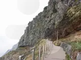
The trail running along the left coast of Dodong Pier offers stunning scenery. Visitors can admire the coastal beauty unfolding between natural caves and bridges connecting the valleys. The coastal trail leads to a village called Haengnam. This village is also called 'Salguknam' after a large apricot tree said to have once stood at its entrance. \nAbout 400m from the village stands Haengnam Lighthouse, which lights the way for distant sea routes. The lighthouse path, lined with black pines, is a spectacular sight in autumn when clusters of yellow farfugium flowers bloom. From the lighthouse, you can enjoy the scenic view of Jeodong Harbor. (The coastal trail takes about 1 hour 30 minutes round trip.)\nMoreLess
Source: Korea Tourism Organization (TourAPI) · Machine-translated